Library Record
Images
Metadata
Title |
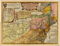
Geographical, Historical, Political, Philosophical, and Mechanical Essays. First, Containing...a General Map of the Middle British Colonies in America... |
Published Place |
Pennsylvania, Philadelphia |
Author |
Evans, Lewis (1700-1756) |
Published Date |
1755 |
Physical Description |
Folio. Ink on Wove Paper, Moire-covered bookboards Length: 11 1/4" Width: 8 1/4" 25 Pages; 40 sides printed |
Summary |
Published by Benjamin Franklin (1706-1790) and David Hall (1714-1772), this collection of essays by surveyor Lewis Evans include a large folding map of British colonies in America drawn by the author and etched by James Turner in Philadelphia. The essays describe details about the colonies, including Indian affairs, politics, warnings, and navigations, and outline the importance of the Ohio Valley in Great Britain's battle with the French for dominance in North America. The map also identifies the lands claimed by various Indian nations. Copies of the publication were intended for sale in England and have the added line on the title page: "And sold by R. and J. Dodsley, in Pall-Mall, London." |
Provenance |
Huntington Library duplicate, 1942 Thomas W. Streeter (1883-1965) Soethby's Parke-Bernet, New York, New York, April 19-20, 1967, The Streeter Sale, Lot 819 Purchased by The Dietrich American Foundation (Charles Sessler, Philadelphia, Pennsylvania, agent), 1967 |
Object Name |
Book |
Object ID |
101.167 |
Search Terms |
book books map maps |